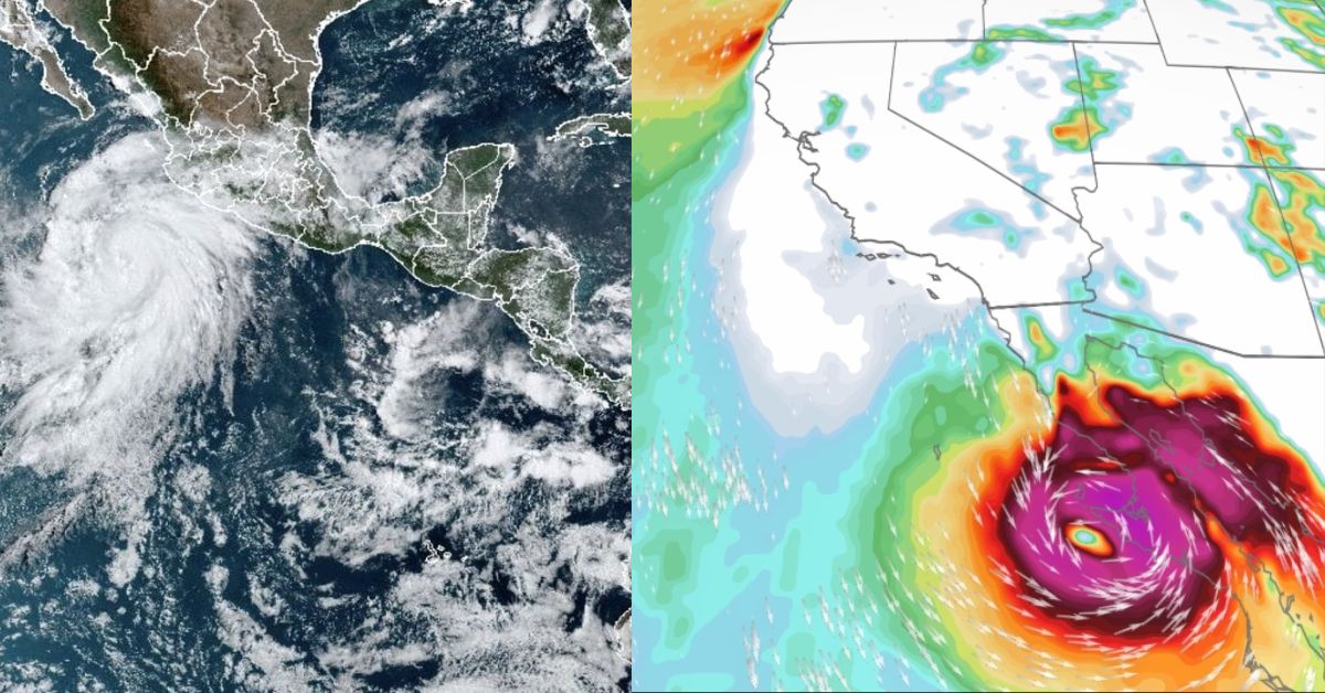
Hurricane Hilary is still moving toward the coast of Mexico, and its effects have already reached the Southwest of the United States. After the storm’s effects on Mexico, high seas, gusting winds, and potentially catastrophic, life-threatening flooding will affect the Southwest of the United States.
The maps from the FOX Forecast Center below display the most recent data on Hilary’s estimated course, active watches and warnings, expected rainfall totals, and more. For more details read the full post…
Hurricane Hilary
According to the National Weather Service, Hurricane Hilary has been downgraded from a category 3 storm on Saturday afternoon to a category 2 hurricane with gusts of 110 mph as of 5 p.m. ET.
As Hilary interacts with the mountainous topography of Baja California on Sunday and moves into colder ocean waters, it will quickly weaken. Hilary will make landfall as a tropical storm late Sunday or early Monday in Southern California.
Flooding has the potential to be catastrophic and life-threatening. Tropical Storm Warnings have been issued for Southern California for the first time ever. Since September 25, 1939, no tropical storm has made landfall in Southern California, according to the National Weather Service.
About 95 miles to the west-northwest of Socorro Island, Hilary’s center was located. It was traveling 12 mph in the northwest.
Ocean Temperatures

For hurricanes to survive, the ocean must be over 80 degrees. Hilary will continue to swim in the warm waters through Saturday. The water is currently 85 degrees. Ocean temperatures along the California coast will quickly drop into the 70s and eventually, the 60s as Hilary approaches Baja California.
Although that change in temperature may not seem like much, ocean water in the 60s cannot maintain a tropical system, and water in the 70s will effectively kill Hilary. As a result, as the system gets closer to the California–Mexico border, we observe a very quick weakening.
You might be interested in reading some of our other articles about tragic events that happened near your area. You should check the links given below:
- Kaylin Gillis: New York Woman Shot Dead After Buddy Pulled Into Wrong Driveway
- Four Americans Were Kidnapped in Mexico: 2 Dead, 2 Alive
Heavy Rain Threat in Socal
Southern California may experience significant floods as a result of Hilary’s precipitation. San Diego and Los Angeles counties will be under a flood watch from tomorrow at 11 a.m. until Monday night, according to the National Weather Service.
Across parts of southern California and southern Nevada, rainfall levels of 3 to 6 inches are anticipated, with lone amounts of 10 inches. This would have substantial and unusual effects. Rainfall amounts of 1 to 3 inches are anticipated elsewhere in parts of the Western United States. Southern California will also be affected by rough waves and heavy gusts.
Central Valley Impacts
By Monday and Tuesday, Hurricane Hilary is expected to have left behind rain and thunder in the Central Valley. By Monday morning, the South Valley may get its first rain. By Monday afternoon, there will be a risk of thunderstorms across the whole of the Central Valley.
As the Valley is still a few days away from the storm and there is a chance that Hilary can weaken, projected rain totals keep changing.
Bay Area Impacts
The majority of the moisture is kept in Southern California and the Sierra due to Hilary’s present track, but we still have a chance of seeing a few scattered showers here on Sunday and a chance of showers on Monday.
Between Sunday and the beginning of next week, Hilary’s remnants will bring greater humidity and tropical cloud cover. We will keep an eye on the storm’s progress, and any slight changes might enhance the likelihood of rain in this area. We will make adjustments to that in the upcoming days.
For more details see the tweet below:
The rain situation in #California does not look scary on this map, but it is. #HurricaneHilary pic.twitter.com/QxTLt9b2nU
— Weather and Climate Tracker (@GizmoWeather) August 20, 2023


